- Home Page /
- Electronics /
- GPS, Finders & Accessories /
- Sports & Handheld GPS /
- Handheld GPS Units /
- E1 GNSS IMU RTK GPS Surveying Equipment Rover...
0 ratings


Item #:
80169174
E1 GNSS IMU RTK GPS Surveying Equipment Rover Receiver Rtk Gnss Handheld Collector and Survey Software, 1408 Channels, 1cm Accuracy, 5km Distance
Item #:
80169174
NAD 27550
Price Details
Excluding Shipping & Custom charges ( Shipping and custom charges will be calculated on checkout )
*All items will import from US
30%
In stock
QTY:
Only 7 items left in stock.
Order now and get it around Friday, June 26
Secured transaction
Ubuy works hard to protect your security and privacy. Our advanced payment security system ensures confidentiality by encrypting your information during transmission using AES (Advanced Encryption Standards) and SSL (Secure Socket Layer) protocols. Your payment details are 100% secure as we do not share your payment details with third party sellers.
Our Top Logistics Partners
Experience professional surveying effortlessly with Sfaira ONE's pocket-sized design and 16-hour battery life.
Fast
Shipping
Free
Return*
Secure Packaging
100% Original Products
PCI DSS Compliance

ISO 27001 Certified
Note: Step Down Voltage Transformer required for using electronics products of US store (110-120). Recommended power converters Buy Now.


What Stands Out
Network RTK Rover
Achieve precise positioning with the integrated network RTK rover, ensuring exceptional accuracy for construction and geodetic applications.
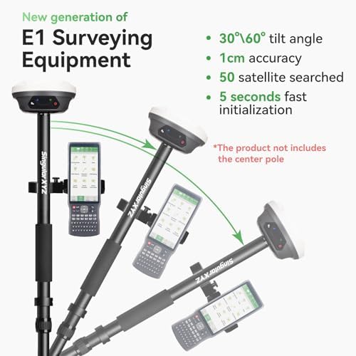
60° Tilt Capability
The 60° tilt feature enhances versatility, allowing users to survey in challenging terrains and tight spaces without compromising data quality.
Built-in IMU
With a built-in IMU, this system provides enhanced stability and reliability, ensuring smooth operation during fieldwork, even in dynamic conditions.
Product Details
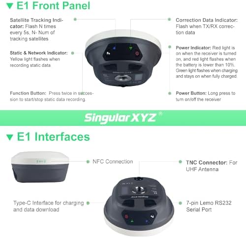
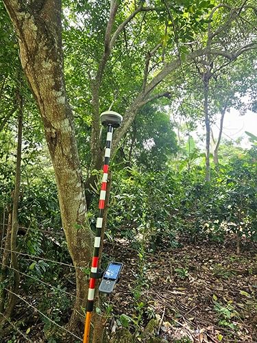
- 【Full-Constellation, Fixed in Seconds】E1 gnss rtk achieves stable fixed solution rapidly, even in challenging environments like multipath, tree canopy, and city canyons.E1 is equipped with a high-precision GNSS engine for simultaneously tracking GPS, BDS, GLONASS, Galileo, QZSS, IRNSS & SBAS.
- 【RTK Corrections Service/CORS Requirement】The E1 rover must connect to an RTK corrections service or a Continuously Operating Reference Station (CORS). You can purchase a third-party RTK service account or set up a GSM base station to get an RTK FIX solution. Check if your location is covered by CORS; you may need to buy local CORS services.
- 【Over 20hrs Operation】With optimized charging safety and internal battery design, E1 gnss survey equipment offers over 20 hours of continuous operation on a single charge, with fast charging support via Type-C port.
- 【5 Kilometers】E1 RTK GNSS Surveying System with IMU has a long transmission distance, Radio range between the rover and the base can reach 5 kilometers (3.1miles). Also E1 can compatible with base stations of other brands in both Radio and CORS mode. Support RTCM v3/CMR correction data transmission.
- 【60° Tilt, 5s Initialization】Our rtk gps equipped with a new generation IMU module, E1 initializes in just 5 seconds and allows tilt measurements up to 60°, ensuring ±2.5cm accuracy for the entire work.
- 【Notes】E1 rtk gnss of surveying software already installed in Handheld and Permanently valid.E1 GNSS receiver is compatible with regular 5/8" thread range poles.
- 【Smaller, Lighter】E1 rtk gnss survey equipment is compact and lightweight, with dimensions of 5.25 × 2.63 inches and a weight of 1.92 lb, ensuring ease of use without sacrificing performance.
- Note: U.S. users must apply for an FCC radio license for commercial use (e.g., surveying, construction) with the UHF function (450–470 MHz). The device is FCC certified, and we can provide supporting info if needed.
| Compatible with Vehicle Type | Car, Truck |
| Screen Size | 1 Inches (2.5 cm) |
| Additional Features | Bluetooth, NFC, Waterproof |
| Connectivity Technology | Bluetooth, Ethernet, USB, Wi-Fi |
| Map Types | Worldwide |
| Battery Average Life | 20 Hours |
| Mounting Type | Panel Mount |
| Operating System | Android |
| Memory Storage Capacity | 8 GB |
| Touch Screen Type | Capacitive |
| Display Type | LCD, LED |
| Human-Interface Input | Buttons |
| Compatible Devices | Data collectors, Tablet |
| Control Method | App |
| Are Batteries Included | Yes |
| Supported Satellite Navigation System | BeiDou, GLONASS, GPS, Galileo |
| Connectivity Protocol | Bluetooth, Matter, NFC, Wi-Fi |
| Brand | SingularXYZ |
| Model Name | E1 GNSS RECEIVER |
| Built-In Media | E1 GNSS Receiver *1, Transport Case*1, USB-Type C Cable*1, Super Charger*1, Quick Start Guide*1, Quick Start Card*1, SC260 Data Collector*1, USB cable *1, Super Charger *1, Bracket*1, SingularPad Software*1, Terminal antenna*1 |
| Model Year | 2024 |
| Manufacturer | SingularXYZ |
| Model Number | E1 GNSS RECEIVER |
| Mfr Part Number | E1 GNSS RECEIVER |
| Item Type Name | surveying equipment; handheld gps for surveying; land surveying equipment; surveying gps; survey equipment; rtk; gnss; gps surveying equipment; gnss rtk; total station surveying equipment; rtk gps; gps rtk; gps gnss rtk; gnss receiver;gps rover and base |
| Item Dimensions L x W x H | 2.64"L x 5.26"W x 5.26"H (6.7 x 13.4 x 13.4 cm) |
| Item Weight | 7.8 Pounds (3.54 kg) |
| Vehicle Service Type | Car, Truck |
| Special Feature | Bluetooth, NFC, Waterproof |
| Map Type | Worldwide |
| Included Components | E1 GNSS Receiver *1, Transport Case*1, USB-Type C Cable*1, Super Charger*1, Quick Start Guide*1, Quick Start Card*1, SC260 Data Collector*1, USB cable *1, Super Charger *1, Bracket*1, SingularPad Software*1, Terminal antenna*1 See more |
| Battery Life | 20 Hours |
Who Should Buy?

-
Surveying Professionals
Ideal for land surveyors requiring precision and reliability in geodetic survey data collection and analysis.
-
Construction Teams
Great for construction managers needing accurate layout planning and monitoring of projects with high precision.
-
Geospatial Analysts
Beneficial for analysts working on GIS projects needing detailed positional data with tilt compensation features.

-
Casual Users
Not suitable for individuals who only need basic measurement tools without advanced functionalities or precision.
-
Small Projects
Less ideal for small-scale projects that don’t require high accuracy or complex surveying methodologies.
-
Budget-Conscious Buyers
May not fit those seeking economical solutions, as RTK GNSS technology can be relatively expensive.
Product Description
Have any Query? Chat with us
Customer Questions & Answers
-
Question:
What is RTK GNSS Survey Equipment and how does it work?
Answer: RTK GNSS Survey Equipment stands for Real-Time Kinematic Namibia Navigation Satellite System, which is designed to provide precise location data. It utilizes signals from multiple satellites to determine the exact position of survey points, often within a centimeter accuracy. RTK works primarily through a base station that transmits corrections to a rover unit, which can be handheld for convenience. This system is essential in tasks like construction planning, geodetic surveys, and land mapping, where accurate spatial data is critical. -
Question:
What are the key features of the Rover Handheld GPS?
Answer: The Rover Handheld GPS boasts portability, precision, and advanced connectivity features. It is built to withstand various environmental conditions while providing accurate position data. Key features typically include a high-resolution display, long-lasting battery life, and compatibility with various survey software applications. Ideal for field surveys in construction projects, it enables surveyors to collect data efficiently and effectively, streamlining workflows and enhancing productivity. -
Question:
What is included in the RTK GNSS Survey Equipment package?
Answer: Typically, the RTK GNSS Survey Equipment package includes a rover handheld GPS, a base station, a handheld controller, and essential survey software. These components work together to capture and process geospatial data accurately. The software often includes mapping tools and features that facilitate real-time data management. This comprehensive setup meets the needs of professionals in construction and geodetic surveys, ensuring effective and efficient project execution. -
Question:
How can I use RTK GNSS for construction surveys?
Answer: RTK GNSS technology is invaluable for construction surveys, allowing for precise measurements of site features and boundaries. Surveyors can use the handheld GPS to establish control points, stakeout locations, and monitor site progress with high accuracy. Incorporating RTK GNSS reduces the chances of errors in measurements, helping to ensure that construction complies with design specifications, thus improving overall project quality and time efficiency. -
Question:
Can RTK GNSS equipment be used for geodetic surveys?
Answer: Yes, RTK GNSS equipment is highly suitable for geodetic surveys, providing the precision required for measuring large-scale geographic features. Geodetic surveys often involve creating vast mapping projects and establishing reference points across long distances. Using RTK technology allows surveyors to collect high-accuracy data quickly, which is crucial for tasks such as land registration, topographic mapping, and boundary delineation. -
Question:
What survey software is compatible with RTK GNSS equipment?
Answer: A variety of survey software is compatible with RTK GNSS equipment, including options like Surfer, Carlson Survey, and Trimble Business Center. These software solutions enable users to process and analyze the data collected via the GNSS equipment. They often include tools for creating maps, conducting data corrections, and generating reports, which are essential for professionals managing construction and land surveying projects. -
Question:
Is training required to operate RTK GNSS Survey Equipment?
Answer: While basic operation of RTK GNSS Survey Equipment can be learned quickly, training is highly recommended to maximize its potential. Understanding the intricacies of GNSS technology, error correction strategies, and data collection techniques greatly enhances operational efficiency. Many manufacturers and suppliers offer training sessions or tutorials to help users become skilled in using RTK systems for surveying tasks, ensuring better results in the field. -
Question:
What are the advantages of using a handheld controller with GNSS equipment?
Answer: A handheld controller enhances the usability of GNSS equipment by providing a user-friendly interface for operation in the field. It often includes features like touchscreens and intuitive navigation, making it easy to manage data collection and monitoring. This setup is especially beneficial in construction and surveying operations where surveyors must quickly adjust settings, manage settings, and review data in real time, leading to improved accuracy and workflow efficiency. -
Question:
What is the range of RTK GNSS Survey Equipment?
Answer: The operational range of RTK GNSS Survey Equipment can vary based on the base station setup and environmental conditions but generally extends several kilometers. Obstacles like buildings or dense vegetation can affect signal reception. By using additional communication technology, such as cellular networks or radio links, surveyors can enhance the range and reliability of the GNSS system, ensuring effective data collection across large survey areas. -
Question:
Where can I buy RTK GNSS Survey Equipment in Namibia?
Answer: You can buy RTK GNSS Survey Equipment with Rover Handheld GPS from Ubuy in Namibia. Ubuy offers a wide range of surveying equipment, ensuring you have access to high-quality tools essential for construction, geodetic, and land surveying tasks. With Ubuy’s platform, you can explore various brands and options tailored to meet your specific surveying needs efficiently.
SingularXYZ Handheld GPS Units E1 GNSS RECEIVER Editorial Review


The Safia One Plus rover has gathered positive reviews from users, with the tilt correction feature being highlighted as a game-changer. Users appreciate the rover's light and small design and its ability to acquire good reception. Some minor inconveniences were noted, such as the need to perform tilt calibration at each boot up and LED indicators that could provide more information on the fix status and battery percentage. Overall, customers were pleased with the performance of the rover. On the other hand, feedback on the data collector was mixed. Users found the hardware impressive, citing features like a bright screen, responsive touch screen, camera shortcut, and good battery life. However, there were concerns about the initial functionality issues with the SIM card and connectivity to the rover, which required a factory reset to resolve. Additionally, the presence of Mobile Device Management (MDM) software on the collector raised privacy concerns for some users. It was mentioned that customer service had to be contacted to disable the MDM software, but root access was not provided. The continuous data connection to mainland China through the survey software was also flagged as a potential privacy issue. Despite the challenges with the data collector, the Safia One Plus rover was commended for its performance when used with NTrip RTK corrections. Users found it suitable for a variety of surveying tasks, including locating ground control points for drone projects and standard boundary and topo surveys. The device was noted for its fast GPS fix, efficient data collection, and the ability to provide sub-centimeter accuracy as advertised. Users appreciated the convenience of not needing a separate base station and the inclusion of the surveying software. Overall, the Safia One Plus rover offers impressive features and performance for surveying tasks, with the added advantage of tilt correction capability. However, potential buyers should be mindful of the data privacy issues associated with the data collector and continuous data connection to mainland China. **
Customer Reviews & Ratings
11 customers ratings
-
5 Star
48%
-
4 Star
16%
-
3 Star
7%
-
2 Star
15%
-
1 Star
14%
Review this product
Share your thoughts with other customers
Pros
- Tilt correction feature is a game-changer
- Lightweight and compact design
- Good reception and fast GPS fix
- Suitable for various surveying tasks without a separate base station
- Sub-centimeter accuracy
Cons
- Privacy concerns related to Mobile Device Management software and continuous data connection to mainland China
Product Price History
Important information
- Limitations : For products shipped internationally, please note that any manufacturer warranty may not be valid; manufacturer service options may not be available; product manuals, instructions, and safety warnings may not be in destination country languages; the products (and accompanying materials) may not be designed in accordance with destination country standards, specifications, and labeling requirements; and the products may not conform to destination country voltage and other electrical standards (requiring use of an adapter or converter if appropriate). The recipient is responsible for assuring that the product can be lawfully imported to the destination country. When ordering from Ubuy or its affiliates, the recipient is the importer of record and must comply with all laws and regulations of the destination country.
- Not all the products listed on Ubuy are for sale, as Ubuy is a global search engine. Products are subject to export/trade regulations.
NAD 27550
Order now and get it around Friday, June 26
This item is not restrict in my country.(Please click on above link if this item is not restrict in your country, So our team will review and allow.)
QTY:
Only 7 items left in stock.
Secured transaction
Ubuy works hard to protect your security and privacy. Our advanced payment security system ensures confidentiality by encrypting your information during transmission using AES (Advanced Encryption Standards) and SSL (Secure Socket Layer) protocols. Your payment details are 100% secure as we do not share your payment details with third party sellers.
Our Top Logistics Partners
Fastest cross-border delivery
Features & Benefits
- Pocket-sized design for easy portability.
- 1408 channels for full-constellation tracking.
- Impressive 16-hour battery life ensures long working sessions.
- Connects easily via Bluetooth and supports extensive surveying applications.
- Integrates seamlessly with multiple file formats for import and export.
- Comprehensive support through tutorials, manuals, and technical assistance.