- Home Page /
- Office Products /
- Office & School Supplies /
- Education & Crafts /
- Geography Materials /
- Maps /
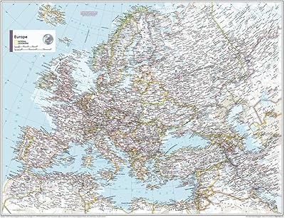
- National Geographic Maps: Europe Political Wa...
0 ratings

Item #:
75224354
National Geographic Maps: Europe Political Wall Map - Compact - 21.5 x 16.25 inches
Item #:
75224354
NAD 605
Price Details
Excluding Shipping & Custom charges ( Shipping and custom charges will be calculated on checkout )
*All items will import from US
0 ratings
Write a review
In stock
QTY:
Order now and get it around Friday, June 26
Secured transaction
Ubuy works hard to protect your security and privacy. Our advanced payment security system ensures confidentiality by encrypting your information during transmission using AES (Advanced Encryption Standards) and SSL (Secure Socket Layer) protocols. Your payment details are 100% secure as we do not share your payment details with third party sellers.
Our Top Logistics Partners
Your laminated map has a glossy finish so that you can use dry erase markers on the map to highlight features, make plans, and share unique information with others.
Fast
Shipping
Free
Return*
Secure Packaging
100% Original Products
PCI DSS Compliance

ISO 27001 Certified
Note: Step Down Voltage Transformer required for using electronics products of US store (110-120). Recommended power converters Buy Now.


What Stands Out
Compact Size
Measuring 21.5 x 16.25 inches, this wall map is ideal for limited spaces while still providing clear visibility of European political boundaries and features.
High-Quality Detail
Produced by National Geographic, this map features vibrant colors and precise details that enhance understanding of Europe’s geography, making it suitable for educational purposes or personal use.
Durable Material
Printed on quality paper, this wall map is designed to withstand fading and wear, ensuring it remains a long-lasting reference piece for home or office décor.
Product Details
| Item Weight | 1.5 lbs (680 grams) |
Who Should Buy?

-
Teachers
Ideal for educators looking to enhance geography lessons and provide visual aids for students learning about Europe.
-
Travel Enthusiasts
Perfect for those planning trips across Europe, offering a clear overview of countries and political boundaries.
-
Office Decor
A great addition to a workspace, providing both aesthetic value and educational reference for employees and clients.

-
Detail-Oriented Users
Individuals requiring high detail for specific geographic features may find the map too compact and limited.
-
Outdoor Use
Not suitable for outdoor activities or rugged environments, as the lamination is not intended for wear and tear.
-
Budget-Conscious Buyers
Those looking for a low-cost or basic map may find this product relatively expensive for its size.
Product Description
National Geographic Maps: Europe Political Wall Map - Compact - 21.5 x 16.25 inches
Have any Query? Chat with us
Customer Questions & Answers
-
Question:
What is the size of the National Geographic Europe Political Wall Map?
Answer: The National Geographic Europe Political Wall Map measures 21.5 x 16.25 inches. This compact size makes it suitable for a variety of spaces, whether it's a classroom, office, or even a home study area. Despite its smaller dimensions, the detailed cartography and vibrant colors ensure that the map remains visually engaging and informative. It's perfect for anyone wanting to enhance their geographical knowledge or decorate a space with an educational touch. -
Question:
What features can I find on the Europe Political Wall Map?
Answer: This wall map features political boundaries, major cities, rivers, and prominent geographical landmarks. Each feature is clearly labeled and designed in a way that makes it easy to read from a distance. The vibrant colors differentiate countries and regions, enhancing visual understanding. Ideal for educators and students, this map facilitates learning about European countries and their capitals in a straightforward and engaging manner. -
Question:
Is the Europe Political Wall Map suitable for educational purposes?
Answer: Yes, the Europe Political Wall Map is an excellent educational tool. It provides a clear representation of European political boundaries and geographical features, making it useful for history lessons, geography classes, and even language studies focused on different countries. Teachers can use it to illustrate discussions about European politics or geography, while students can reference it for projects or assignments. -
Question:
What materials are used for the National Geographic Europe Political Wall Map?
Answer: This wall map is printed on high-quality paper, ensuring durability and vivid color reproduction. The map is designed to withstand the test of time, which is essential for classroom and home use. Its sturdy construction allows it to be hung on walls without worry of damage from handling. For those looking to create a learning environment or simply adorn a wall, this map serves as both an educational tool and a decorative piece. -
Question:
Can I frame the Europe Political Wall Map?
Answer: Absolutely! The compact size of the map lends itself well to framing, allowing you to display it as an attractive piece of wall art. Framing your National Geographic Europe Political Wall Map not only enhances its visual appeal but also helps to protect it from wear and tear. Many people choose to frame maps for personal use or as thoughtful gifts, creating a timeless treasure for homes, offices, and educational settings. -
Question:
What is the best use for the Europe Political Wall Map?
Answer: The best use of the Europe Political Wall Map includes educational purposes, home decoration, and travel planning. Students and educators find it beneficial for visual learning, while travelers may use it to plan their trips or to understand political contexts of the countries they are visiting. Additionally, it can be a unique conversation starter when displayed in a living room or study, sparking interest in European cultures and geography. -
Question:
Does the map include country names in multiple languages?
Answer: The Europe Political Wall Map primarily features country names in English, providing a consistent and accessible reference point for English speakers. While it may not include multiple languages like some multilingual maps, its clarity allows users to easily recognize and understand the political divisions of Europe. This feature makes it an efficient educational resource for English-speaking students and learners, aiding in geographical literacy. -
Question:
Is there any extra information provided on the map?
Answer: Yes, the National Geographic Europe Political Wall Map includes additional geographic information such as major rivers and mountain ranges. These features enhance the user's understanding of the physical landscape in conjunction with political boundaries. This type of comprehensive information makes it a valuable resource for both casual users and those deeply interested in European geography and politics. -
Question:
What types of spaces is the Europe Political Wall Map ideal for?
Answer: The compact dimensions of the Europe Political Wall Map make it ideal for a variety of spaces including classrooms, home offices, and study areas. Its engaging design and educational content make it a great fit for schools where it can serve as a teaching aid. Meanwhile, it can also elevate the ambiance of a home decor setting, making it relevant for personal use in living rooms or studies. -
Question:
Where can I buy the National Geographic Maps: Europe Political Wall Map - Compact in Namibia?
Answer: You can buy the National Geographic Maps: Europe Political Wall Map - Compact at Ubuy in Namibia. Ubuy offers a user-friendly shopping experience, providing a convenient platform to explore various map options and get your desired product simply and effectively.
NationalGeographic Maps Editorial Review
No editorial reviews found
Customer Reviews & Ratings
1 customers ratings
-
5 Star
100%
-
4 Star
0%
-
3 Star
0%
-
2 Star
0%
-
1 Star
0%
Review this product
Share your thoughts with other customers
Pros
- High-quality front lamination
- Detailed political boundaries
- Compact size for easy display
- Vibrant colors and prints
- Durable and tear-resistant material
Cons
- Limited to political features
Product Price History
Important information
- Limitations : For products shipped internationally, please note that any manufacturer warranty may not be valid; manufacturer service options may not be available; product manuals, instructions, and safety warnings may not be in destination country languages; the products (and accompanying materials) may not be designed in accordance with destination country standards, specifications, and labeling requirements; and the products may not conform to destination country voltage and other electrical standards (requiring use of an adapter or converter if appropriate). The recipient is responsible for assuring that the product can be lawfully imported to the destination country. When ordering from Ubuy or its affiliates, the recipient is the importer of record and must comply with all laws and regulations of the destination country.
- Not all the products listed on Ubuy are for sale, as Ubuy is a global search engine. Products are subject to export/trade regulations.
NAD 605
Order now and get it around Friday, June 26
This item is not restrict in my country.(Please click on above link if this item is not restrict in your country, So our team will review and allow.)
QTY:
Secured transaction
Ubuy works hard to protect your security and privacy. Our advanced payment security system ensures confidentiality by encrypting your information during transmission using AES (Advanced Encryption Standards) and SSL (Secure Socket Layer) protocols. Your payment details are 100% secure as we do not share your payment details with third party sellers.
Our Top Logistics Partners
Fastest cross-border delivery
Features & Benefits
- Compact size of 21.5 x 16.25 inches, perfect for wall poster collections.
- High-quality print with a glossy finish, allowing for dry erase marker usage.
- Durable lamination, resistant to folding or ripping.
- Shipped rolled in a sturdy tube for protection during transport.
- A collectible item, available individually for the first time.
- Backed by National Geographic's iconic and trusted cartography.